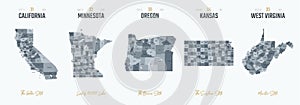
vector set highly detailed silhouettes state maps divided into counties with names and territory nicknames |
||||||||||||||||||||||||||||||||||||||||
navigate by keyword : administrative america american angeles area border borough california cartography charleston city contour counties country county cut design detailed district divided division emblems francisco geography highly icon isolated kansas land local logo los map maps minneapolis minnesota names nicknames oregon outline plan portland postage poster region sacramento san set silhouette silhouettes stamp state subdivision territory travel usa vector virginia west |
||||||||||||||||||||||||||||||||||||||||
|
||||||||||||||||||||||||||||||||||||||||
Vector set 7 of 10 Highly detailed silhouettes of US state maps, divided into counties with names and territory nicknames for design |
||||||||||||||||||||||||||||||||||||||||
Stockphotos.ro (c) 2025. All stock photos are provided by Dreamstime and are copyrighted by their respective owners. |