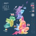
vector map united kingdom colored countries counties and regions

navigate by keyword : and antrim britain cheshire country county cymru derbyshire derry devon dyfed east england english essex fife flag geography glamorgan glasgow greater gwent highlands humber illustration ireland kent kingdom leicestershire london lothian manchester map merseyside mid midlands norfolk north northern powys region scotland south suffolk travel tyne tyrone united vector wales wear west yorkshire

Vector map of United Kingdom administrative divisions colored by countries and regions. Districts and counties map of England, Wal Royalty Free Stock Photo
Vector map of British Isles administrative divisions colored by countries and regions. Royalty Free Stock Photo
Vector map of United Kingdom colored by countries, counties and regions Royalty Free Stock Photo


Vector map of United Kingdom colored by countries, counties and regions


Vector map of United Kingdom colored by countries, counties and regions


Stockphotos.ro (c) 2025. All stock photos are provided by Dreamstime and are copyrighted by their respective owners.