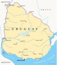
uruguay political map with capital montevideo most important cities national borders |
||||||||||||||||||||||||||||||||||||||||
navigate by keyword : tacuarembo salto rivera plata paysandu negro merin melo maldonado laguna artigas argentina america geography south country mercedes republic atlantic atlas coastline cartography brazil ocean world globe travel vector abstract uruguai rio montevideo uruguay map |
||||||||||||||||||||||||||||||||||||||||
|
||||||||||||||||||||||||||||||||||||||||
Uruguay Political Map featuring the capital Montevideo, major cities, and clearly marked national borders. Ideal for educational, travel, and infographic purposes |
||||||||||||||||||||||||||||||||||||||||
Stockphotos.ro (c) 2025. All stock photos are provided by Dreamstime and are copyrighted by their respective owners. |