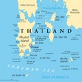
| phuket largest island thailand political map with surrounding area | ||||||||||||||||||||||||||||||||||||||||
| navigate by keyword : andaman archipelago area asia asian atlas bay beach cartography coconut coral country destination geography group illustration island islands kingdom land lon malacca malay map nga noi patong peninsula phang phi phuket political popular region sea siam siray strait thai thailand tourism tourist travel vector yai yao | ||||||||||||||||||||||||||||||||||||||||
| 
 | ||||||||||||||||||||||||||||||||||||||||
| Phuket, largest Island of Thailand, political map with surrounding area. Popular tourist region with plenty of islands, south of Malay Peninsula, in the Andaman Sea and north of the Strait of Malacca. | ||||||||||||||||||||||||||||||||||||||||
| Stockphotos.ro (c) 2025. All stock photos are provided by Dreamstime and are copyrighted by their respective owners. | ||||||||||||||||||||||||||||||||||||||||