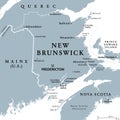
new brunswick maritime and atlantic province canada political map |
||||||||||||||||||||||||||||||||||||||||
navigate by keyword : america americas atlantic atlas bathurst bay border boundary brunswick canada canadian capital cartography charlottetown country edmundston edward fredericton fundy geography gulf halifax illustration island john lawrence maine map mapping maritime maritimes miramichi moncton nation new north northumberland nova overview political prince province quebec saint scotia state states strait travel united vector |
||||||||||||||||||||||||||||||||||||||||
|
||||||||||||||||||||||||||||||||||||||||
New Brunswick, Maritime and Atlantic province of Canada, political map. Bordered to Quebec, Nova Scotia, Gulf of St. Lawrence, Bay of Fundy and US state Maine, with capital Fredericton. Illustration. |
||||||||||||||||||||||||||||||||||||||||
Stockphotos.ro (c) 2025. All stock photos are provided by Dreamstime and are copyrighted by their respective owners. |