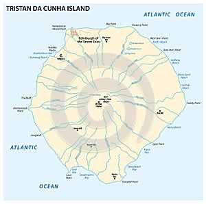
map tristan cunha island the atlantic ocean british overseas territory

navigate by keyword : africa african archipelago area ascension atlantic background bay beach blue british city country county cunha department design detail division edinburgh flat geography graphic illustration island islands land location map modern national ocean oversea overseas point region regional shape silhouette simple south state territory travel trip tristan vector

Map Tristan da Cunha Island in the Atlantic Ocean British Overseas Territory Royalty Free Stock Photo
Tristan da Cunha, Inaccessible, Nightingale and Gough Island, gray map Royalty Free Stock Photo
Tristan da Cunha, Inaccessible, Nightingale and Gough Island political map Royalty Free Stock Photo
Tristan de Cunha island map - cdr format Royalty Free Stock Photo
   
   
Map Tristan da Cunha Island in the Atlantic Ocean British Overseas Territory
Saint Helena, Ascension and Tristan da Cunha, political map Royalty Free Stock Photo
Saint Helena, Ascension and Tristan da Cunha, gray political map Royalty Free Stock Photo
   
Saint Helena, Ascension and Tristan da Cunha map Royalty Free Stock Photo
Tristan da Cunha Flag Tag Royalty Free Stock Photo
South Atlantic Islands, gray political map Royalty Free Stock Photo
South Atlantic Islands, between Africa and Brazil,  political map Royalty Free Stock Photo
Map Tristan da Cunha Island in the Atlantic Ocean British Overseas Territory.


Stockphotos.ro (c) 2025. All stock photos are provided by Dreamstime and are copyrighted by their respective owners.