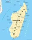
madagascar political map and capital antananarivo with national borders important cities |
||||||||||||||||||||||||||||||||||||||||
| navigate by keyword : tyle world map chart flag ocean worldwide antananarivo line texture color tourism art african territory international shape region location earth symbol land national state design nation icon political continent graphic outline atlas cartography africa background border travel geography country madagascar |
||||||||||||||||||||||||||||||||||||||||
|
||||||||||||||||||||||||||||||||||||||||
| Madagascar political map featuring its capital, Antananarivo, with national borders and important cities like Toamasina, Antsirabe, Fianarantsoa, and Mahajanga |
||||||||||||||||||||||||||||||||||||||||
|
Stockphotos.ro (c) 2025. All stock photos are provided by Dreamstime and are copyrighted by their respective owners. |
||||||||||||||||||||||||||||||||||||||||