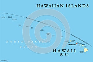
hawaiian islands political map the state hawaii and midway island

navigate by keyword : aloha america american archipelago atlas atoll big capital cartography geography hawaii hawaiian honolulu hotspot illustration island islands kauai leeward map mapping maui midway molokai niihau north northeastern oahu ocean oceania pacific plate polynesia sandwich southeastern state states territory unincorporated united usa vector volcanic windward

Hawaiian Islands, political map, the state of Hawaii and Midway Island Royalty Free Stock Photo
Hawaiian Islands, Sandwich Islands, gray political map Royalty Free Stock Photo
Hawaiian Islands, archipelago in the Pacific Ocean, gray political map Royalty Free Stock Photo
Hawaiian Islands, archipelago in the Pacific Ocean, political map Royalty Free Stock Photo


Hawaiian Islands, political map, the state of Hawaii and Midway Island


Hawaiian Islands, political map. U.S. state of Hawaii with capital Honolulu and the unincorporated territory Midway Island. Archipelago in North Pacific Ocean. Sandwich Islands. Illustration. Vector.


Stockphotos.ro (c) 2025. All stock photos are provided by Dreamstime and are copyrighted by their respective owners.