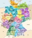
germany high detailed vector map with neighbouring countries and territories |
||||||||||||||||||||||||||||||||||||||||
navigate by keyword : anhalt background baden bavaria bayern berlin borders brandenburg bremen capital cartography city colored country darmstadt deutschland division europe european geography germany hamburg hesse holstein illustration isolated koln land lower map mecklenburg national navigation nordrhein north oberbayern oberpfalz palatinate political region rhine rhineland saarland saxony schleswig schwaben state subdivision territory thuringia travel vector vorpommen westfalen westphalia wuttenberg |
||||||||||||||||||||||||||||||||||||||||
|
||||||||||||||||||||||||||||||||||||||||
Germany high detailed vector map with neighbouring countries and territories. Map colored by states and administrative districts, with subdivisions |
||||||||||||||||||||||||||||||||||||||||
Stockphotos.ro (c) 2025. All stock photos are provided by Dreamstime and are copyrighted by their respective owners. |