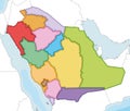
Editable vector map of Saudi Arabia with detailed administrative divisions, political borders, and provinces shaded in various green tones for infographics and data visualization.This vector illustration provides a clear and informative map of the Kingdom of Saudi Arabia, divided into its various administrative regions or governorates. Each region is distinctly shaded in a different tone of green, allowing for easy visual differentiation. The map is presented on a clean white background, making it suitable for a wide range of applications, including geographical studies, political science materials, business presentations focusing on Saudi Arabia, travel and tourism resources, and infographics illustrating regional data. The vector format ensures that the map can be scaled to any size without loss of quality, making it a versatile asset for educational, commercial, and editorial purposes.
|


