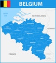
the detailed map belgium with regions states and cities capitals |
||||||||||||||||||||||||||||||||||||||||
| navigate by keyword : abstract administrative and antwerp area arlen atlas background belgium border brabant brussels capital capitals cartography cities city continent contour country detailed district division europe flag gent geographical geography gray hainaut hasselt icon land layout liege limburg mainland map mons nation national origin province region regions scharbeck sharlerua state states surface territory topographic topography vector |
||||||||||||||||||||||||||||||||||||||||
|
||||||||||||||||||||||||||||||||||||||||
| The detailed map of the Belgium with regions or states and cities, capitals |
||||||||||||||||||||||||||||||||||||||||
|
Stockphotos.ro (c) 2025. All stock photos are provided by Dreamstime and are copyrighted by their respective owners. |
||||||||||||||||||||||||||||||||||||||||