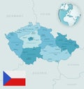
detailed location map czech republic europe with administrative divisions the country vector illustration |
||||||||||||||||||||||||||||||||||||||||
navigate by keyword : administrative area atlas background blue bohemia bohemian border brno cartography central chieshka chieshskii city country czech design detailed district districts division divisions eastern europa europe flag geography globe icon illustration isolated karlovy kraj liberec location map moravia national oblast olomouc ostrava pardubice plzen political prague raion region regions republic silhouette south territory travel vary vector vltav western your zones |
||||||||||||||||||||||||||||||||||||||||
|
||||||||||||||||||||||||||||||||||||||||
Detailed location map of Czech Republic in Europe with administrative divisions of the country, vector illustration, for your design |
||||||||||||||||||||||||||||||||||||||||
Stockphotos.ro (c) 2025. All stock photos are provided by Dreamstime and are copyrighted by their respective owners. |