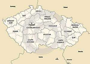
czech republic regions vector map with neighbouring countries and territories

navigate by keyword : administrative area atlas background bohemia border cartography central city colorful country czech design district division europe european geography graphic hradec illustration karlovy kralove land liberec map moravia national olomouc pardubice pilsen plzea political prague province region republic silesia south state subdivision territory tourism travel usti vary vector zlin

Vector map of Czechia or Czech Republic with regions and administrative divisions, and neighbouring countries and territories. Royalty Free Stock Photo
Vector illustrated blank map of Czechia or Czech Republic with regions and administrative divisions, and neighbouring countries Royalty Free Stock Photo
Vector blank map of Czechia or Czech Republic with regions and administrative divisions, and neighbouring countries. Royalty Free Stock Photo
Vector illustrated map of Czechia or Czech Republic with regions and administrative divisions, and neighbouring countries. Royalty Free Stock Photo
Czech Republic regions vector map with neighbouring countries and territories Royalty Free Stock Photo
   
   
Czech Republic regions vector map with neighbouring countries and territories
Czech Republic regions vector map with neighbouring countries and territories Royalty Free Stock Photo


Czech Republic regions vector map with neighbouring countries and territories.


Stockphotos.ro (c) 2025. All stock photos are provided by Dreamstime and are copyrighted by their respective owners.