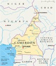
cameroon political map with capital yaounde most important cities national borders |
||||||||||||||||||||||||||||||||||||||||
navigate by keyword : sanaga maroua lagdo isla garoua gabon equatorial ebolowa biafra bafoussam ndjamena lom geography malabo bangui libreville abuja republic atlantic atlas coastline cartography african africa world globe travel abstract douala sao gulf lake guinea tome nigeria congo chad yaound cameroon map |
||||||||||||||||||||||||||||||||||||||||
|
||||||||||||||||||||||||||||||||||||||||
Cameroon political map shows its capital Yaoundé and includes key cities like Douala, Garoua, and Bafoussam, with national borders shared with Nigeria, Chad, Central African Republic, Congo, and Gabon |
||||||||||||||||||||||||||||||||||||||||
Stockphotos.ro (c) 2025. All stock photos are provided by Dreamstime and are copyrighted by their respective owners. |