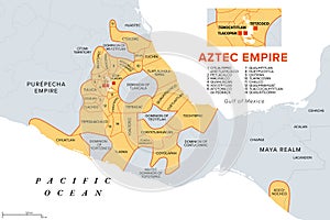
aztec empire with tributary provinces triple alliance history map |
||||||||||||||||||||||||||||||||||||||||
navigate by keyword : aztec empire triple alliance province mexico map history tenochtitlan tetzcoco texcoco tlacopan tacuba valley culhua mexica tributary country state border maximal extent frontier realm maximum spanish conquest maya tlaxcala mesoamerica precolumbian teotitlan mixtec purepecha yopitzinco territory america reign dominion yucatan americas atlas gray orange vector |
||||||||||||||||||||||||||||||||||||||||
|
||||||||||||||||||||||||||||||||||||||||
Aztec Empire with tributary provinces, maximum extent of Triple Alliance, history map. Tenochtitlan, Tetzcoco and Tlacopan at the time of Spanish conquest, 1519. With today state and country borders. |
||||||||||||||||||||||||||||||||||||||||
Stockphotos.ro (c) 2025. All stock photos are provided by Dreamstime and are copyrighted by their respective owners. |