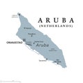
aruba gray political map island the leeward antilles caribbean sea |
||||||||||||||||||||||||||||||||||||||||
navigate by keyword : abc americas antilles aruba atlas background capital caribbean cartography constituent contour country cruise cruz destination dutch english geography gray holland illustration island islands isolated kingdom land leeward lesser map mapping netherlands nicolaas noord oranjestad outline paradera political san santa savaneta sea shape silhouette travel tropical vector white |
||||||||||||||||||||||||||||||||||||||||
|
||||||||||||||||||||||||||||||||||||||||
Aruba, gray political map. Island in the Leeward Antilles in the Caribbean Sea. Constituent country of Kingdom of the Netherlands, capital Oranjestad. Part of ABC islands, off the coast of Venezuela. |
||||||||||||||||||||||||||||||||||||||||
Stockphotos.ro (c) 2025. All stock photos are provided by Dreamstime and are copyrighted by their respective owners. |