map the arabian peninsula middle east physical render with relief and mountains

navigate by keyword : aden arab arabia arabian cartography clouds continent earth east ecology egypt emirates environment forecast geography globe gulf heights iran iraq israel jordan map mediterranean middle mountains nature oman peninsula persian planet qatar red relief render saudi sea state terrain travel united world yemen

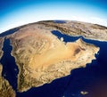
Map of the Arabian Peninsula, Middle East physical map, 3d render, map with relief and mountains. Royalty Free Stock Photo
Map of the Arabian Peninsula, Middle East physical map, 3d render, reliefs and mountains. Royalty Free Stock Photo
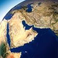
Globe map of the Arabian Peninsula, Middle East physical map. Bathymetry, underwater depth of ocean Royalty Free Stock Photo
Globe map of the Arabian Peninsula, Middle East physical map. United Arab Emirates. Bathymetry, underwater depth of ocean Royalty Free Stock Photo
   
   
Map of the Arabian Peninsula, Middle East physical map, 3d render, map with relief and mountains.
Globe map of the Arabian Peninsula, Middle East physical map. Bathymetry, underwater depth of ocean Royalty Free Stock Photo
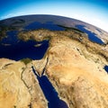
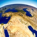
Satellite view of Middle East, physical map. Reliefs and mountains Israel, Turkey, Syria, Iraq, Jordan, Egypt, Iran, Saudi Arabia Royalty Free Stock Photo


Globe map of the Arabian Peninsula, Middle East. India. Bathymetry, underwater depth of ocean Royalty Free Stock Photo
Map of the Arabian Peninsula, Middle East physical map, 3d render, map with relief and mountains. Arabian Sea, Red Sea and Persian Gulf. Yemen, Oman, Saudi Arabia, United Arab Emirates, Iran. Elements of this image are furnished by Nasa


Stockphotos.ro (c) 2025. All stock photos are provided by Dreamstime and are copyrighted by their respective owners.